Toolbox for Human-Earth System Integration and Scaling (THESIS)
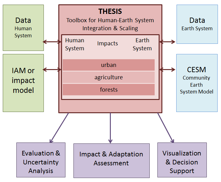 NCAR is coordinating the development of the Toolbox for Human-Earth System Integration and Scaling (THESIS) to facilitate linkages between the Community Earth System Model (CESM) and Integrated Assessment or impact models. THESIS consists of models and software tools to translate, scale, and synthesize information from and between human system models and CESM.
Initial development is focused on urban areas and agriculture, both of which are explicitly represented in the Community Land Model (CLM), the land surface component of CESM. Tools are made available to the community as they are completed. Learn more about the THESIS tools below, or see the THESIS tools license, copyright notice, and disclaimer.
If you are interested in using, further developing, or contributing new tools then contact us via the information below.
Urban System Tools Library
-
- Characterizing urban properties
Constructs properties of urban areas for 33 world regions for input to CLM - Population exposure to climate hazards
Combines gridded CESM output with spatial population projections for use in impact assessment
- Characterizing urban properties
Agriculture and Forest System Tools Library
-
- Spatial projections of agricultural land use
Projects global spatial distribution of cropland and pasture given aggregate regional land use outcomes, for use as input to CLM or the crop yield tool - Agricultural yield
Provides regionally aggregated effect of climate change on crop yields based on projected spatial land use and CLM outcomes - CLM land use data
Generates a transient land use and land cover change input data file for use by CLM5 in CESM2 simulations.
- Spatial projections of agricultural land use
Contact us
For general questions about THESIS, contact Keith Oleson [ oleson@ucar.edu ]
For technical questions about THESIS access and operation, contact Brian Kauffman [ kauff@ucar.edu ]